| The Qinghai-Tibet Plateau was the latest to emerge on earth, but it is the largest in size and the highest in elevation, hence its name as "Roof of the World" or the "Third Pole of the Earth".
Descending from northwest to southeast, the plateau is full of with gullies, glaciers, rocks and Gobi. Under the impact of topography and atmospheric currents, Tibet's climate is varied and diversified. Generally speaking, the climate features frigid and dry air in the northwest and warm and humid air in the southeast. The climatic types from southeast to northwest include tropical, subtropical, plateau temperate, plateau sub-frigid and plateau frigid zones. And the climate undergoes a vertical change from tropical and sub-tropical to temperate, frigid temperate and frigid zones. There is a local saying that "there are four seasons within one mountain" and the "weather changes in a 5-km area" reflecting the diversity.
Himalayan Mountainous Area: Lying in southern Tibet, it is formed by several east-west mountains each with an elevation of 6,000 meters, including the Qomolangma which, located in Tingri County by the China-Nepal border and having an elevation of 8,843.43 meters, is the highest peak in the world. The Himalaya is capped by snow all the year round and climate in its southern and northern side, plus topography, is totally different.
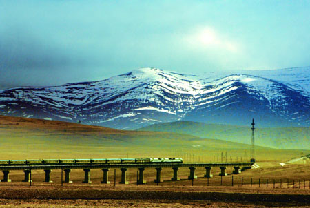
A distant view of the Qinghai-Tibet Railway
Southern Tibet Valley: Lying between the Kangdese and Himalayan mountains, the valley is drained by the Yarlung Zangbo River and its tributaries. This valley is composed of many small sub river and lake valleys. Blessed with flat land and fertile fields, this valley is the major agricultural area of Tibet.
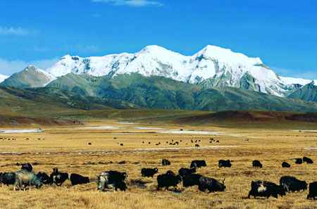
Northern Tibet Plateau: Lying amng the Kunlun, Tanggula, Kangdese and Nyainqentanggula mountains, the plateau occupies two-third of the regional area. Dotted with many basins, this plateau is the major livestock breeding area of Tibet.
Eastern Tibet High Mountain Valley: This refers to the Henduan mountainous area located east of Nagqu. It is composed of a series of east-west and then south-north high mountains and deep ravines. The Nujiang, Lancangjiang and Jinshajiang rivers flow among these mountains. While the top of the mountains are buried under snow, the area on the lower part of the mountain slopes are covwered with trees and crops.
Climate
Exposed to topography and terrain unique to Tibet and air currents, the climate in Tibet is complicated and diversified. Overall, the Tibetan climate features frigid and dry air in the northwest and warm and humid in the southeast, forming climatic zones (southeast-northwest) such as the tropical, subtropical, plateau temperate, and plateau sub-frigid climatic zones. Giving rising elevation, the southeastern Tibet and the southern slope of the Himalayas see lowering temperature, with the temperature pattern featuring changes of going from tropical/sub-tropical to temperate, cold temperate and cold temperate.
With the rise in elevation, reduced air pressure and density, the oxygen content per-cubic meter of air correspondingly declines. At an elevation of 3,000 meters, the oxygen content is already only 73 percent of that at sea level, declining to 62-65.4 percent at 4,000 meters, 59 percent at 5,000 meters and 52 percent at 6,000 meters.
Dominated alternatively by westerly wind in winter and southwesterly wind in summer, Tibet has a clear distinction between dry and wet days. Generally speaking, the months from October to April are a dry season while the months from May to September are a wet season, with precipitation during the period accounts for some 90 percent of the annual total. Rainfall is unevenly distributed in different places of Tibet, with a remarkable demarcation line between dry and rainy seasons. Annual precipitation amounts to 5,000 mm in the low-lying area in the southeastern part, dropping to 50 mm in the northwest.
There exists great difference in climate between southern and northern Tibet. Under the impact of warm humid air currents from the Indian Ocean, the valleys in southern Tibet enjoy warm and wet weather, with the annual average temperature fluctuating between 8-16 degrees Centigrade at the height of summer and -16 degrees Centigrade in the depths of winter. The northern Tibet Plateau enjoys a continental climate, with the annual temperature staying above zero. However, the icing period extends over the bulk of the year. The "hottest" month is July when the average temperature is only 10 degrees Centigrade, however. The period of June-August features warm weather but more rain at night. Spring is windy. March-October is the ideal season for visits and June-September the best season of all. Receant years see the rise in the number of domestic and overseas people who visit Tibet in winter.
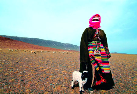
A female shepherd in a Ngaqu pasture
Tibet boasts more solar radiation than any other part of China, about 100 percent or one-third more than in plains at the same latitude. In addition, Tibet enjoys longer duration of sunshine, reaching 3,021 hours annually in Lhasa. However, it is 1,186.84 hours in Chengdu and 1,932.5 hours in Shanghai. The difference in temperature between day and night is enormous in Tibet; however, so far as the whole year is concerned, the seasonal difference is small. Both the annual average temperature and the highest temperature in Lhasa and Xigaze are 10-15 degrees Centigrade lower than in Chongqing, Wuhan and Shanghai, which lie on a closer latitude. The seasonal difference in temperature in Lhasa, Qamdo and Xigaze is 18-20 degrees Centigrade. In the Ngari area, some 5,000 meters above sea level, the temperature in August reaches 10 degrees Centigrade or higher during the day, but falls to below zero at night.
Mountains
On northern Tibet plateau lie the Kunlunshan Mountains and the branch Tanggula Mountain. In southern Tibet, there are the Henduan Mountains. The Kangdese-Nyainqentanglha Mountains bisect Tibet from east to west. Mountains in the region reach an average elevation of over 4,000 meters. But there are 50 peaks each with an elevation of over 7,000 meters and five each rising above 8,000 meters.?
A distant view of the Nyangqentanglha Mountain
Mountains in the plateau basically extend either from east to west or from south to north. Major ones are as the follows:
Himalayan Mountains: Zigzagging through the southern part of the Tibetan Plateau, the Himalayas, the highest and the youngest mountains in the world, comprise many parallel mountains running from east to west. The major part of the Himalayas lies on the border between China and India, and between China and Nepal. Extending some 2,400 km, it is 200-300 km wide. Major peaks have an average elevation of over 6,200 meters. They include the world's highest peak Qomolangma, rising 8,844.43 meters above sea level, towers over surrounding peaks on the Sino-Nepalese border. In this part of the world there are 42 peaks each with an elevation of over 7,000 meters, including four each with an elevation of over 8,000 meters.
Kunlunshan Mountains: Kunlunshan runs west-east on the northwestern fringe of the Tibetan Plateau, with an average elevation of 5,500-6,000 meters. It is one of the places perennially covered under snow and with modern glaciers. Muztag, rising 6,973 meters above sea level, is the highest peak in the area.
Karakorum-Tanggula Mountains: The major part of the Karakorum Mountains lies on the border between Xinjiang and Kashmir. Running eastward, it forms the Tanggula Mountains at 90°E, marking the border between Tibet and Qinghai. Galadandong is its highest peak. Rising 6,621 meters above sea level, it is the source of the Yangtze River, the longest river in China.
Kangdese-Nyainqentanglha Mountains: Lying at the southern edge of the Northern Tibet Plateau, the mountains serve as the border between north and south and southeast Tibet, and the demarcation line for rivers that flow within and out of the region. Kangrinboqe, with an elevation of 6,656 meters, is the main peak of the Kangdese Mountains; and Nyainqentanglha, rising 7,162 meters above sea level, is the highest peak of the Nyainqentanglha Mountains.
Hengduanshan Mountains: Hengduanshan is a combination of several parallel mountains with deep river valleys between them. These mountains from west to east include Bexoi La, Tanian-taweng and Markam mountains. Having an average elevation of 4,000-5,000 meters, they are extensions of the Nyainqentanglha Mountains and Tanggula Mountains.
Rivers
The huge mountains on the Qinghai-Tibet Plateau have bred modern glaciers. Melted ice become the source of many well known rivers in Asia. In Tibet there are more than 20 rivers each with a drainage area of more than 10,000 square km, and over 100 each with a drainage area of more than 2,000 square km. The region has rivers known in the worlde including the Yarlung Zangbo River and its five tributaries such as the Lhasa, Nyang Qu, Nyang, Parlung Zangbo and Dorxung Zangbo. It has the upper reaches of the Yangtze River and the Langcangjiang (its lower reaches called Mekong River), as well as the source of the Nujiang River (its lower reaches called Salween River), plus the Sangge Zangbo (also know as Siquanhe River whose lower reaches is the Hindus River) and Langqen Zangbo River (also known as Xianquanhe River whose lower reaches is the Sutlej River.
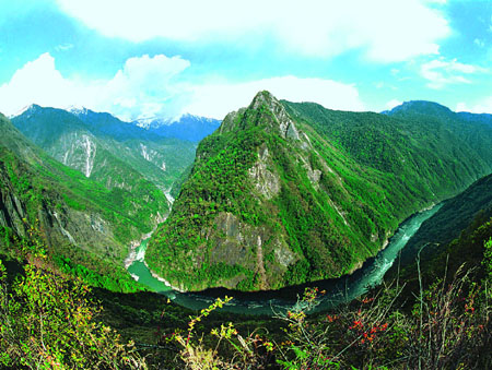
Yanglung Zangbo Grand Canyon
Some of the rivers in Tibet flow into the sea while the others are just inland waters. The most important rivers are the Yarlung Zangbo, Jinshajiang, Lancangjiang, Pum Qu, Langqen Zangbo and Sengge Zangbo. The average annual runoff stands at 448.2 billion cubic meters. Most of the rivers that ultimately empty into the Pacific Ocean or the Indian Ocean are distributed in the border areas of east, south and west Tibet. The inland rivers are mainly distributed on the Northern Tibetan Plateau. Snows on high mountains are headwaters of these rivers, which are usually short and developed surrounding an endorheic lake. Most of them are seasonal waters. Their lower reaches either disappear in the wildness or accumulated into a lake at lower land.
Yarlung Zangbo. Seen as "Mother River" by Tibetans, it is the largest river in the Tibet Autonomous Region. Originating in the Gyima Yangzong Glacier (5,500 meters above sea level) in Zhongba County at the northern foot of the Himalayas, it runs through 23 counties of Xigaze, Lhasa, Shannan and Nyingchi. After leaving Medog County, it becomes Brahmaputra River which empties into the Indian Ocean when passing through India and Bangladesh. The Yarlung Zangbo River runs 2,057 km in China (ranking fifth in China in terms of length), draining an area of 240,000 square km (sixth in China). With the drainage area having an average elevation of 4,500 meters, the Yarlung Zangbo is the highest river in the world. About 1 million people, or 37 percent of Tibet's total population, live in the area drained by the Yarlung Zangbo River, where cultivated land amounts to over 150,000 hectares, or 41.67 percent of the region's total. The area is also home to some major cities and towns, including Lhasa, Xigaze, Gyangze, Zetang and Bayi.
Yarlung Zangbo Grand Canyon. The Yarlung Zangbo River cleaves a straight niche from west to east before reaching the juncture of Mainling and Medog counties, where it swerves around towering Namjagbarwa (7,782 meters), the highest peak in the eastern section of the Himalayas, creating the largest, U-shaped canyon in the world. In 1994, some Chinese scientists made an expedition trip along the canyon. Data published by the State Bureau of Surveying and Mapping following the expedition shows that the canyon starts from the Daduka Village, Mainling County in the north to Parcoka Village, Medog in the south. Stretching 504.6 km, the canyon is 2,268 meters deep on average, with the deepest point being 6,009 meters. The Colorado Canyon in the United States is 440 km in length while the Colca Canyon in Peru is 3,203 meters deep. In September 1998, the State Council officially approved the name of the canyon as "Yarlung Zangbo Daxiagu" (Yarlung Zangbo Grand Canyon).
Lakes
Tibet boasts the largest number of lakes in China. There are some 1,500 lakes covering a total area of 23,800 square km, about 30 percent of the nation's total lake area. They include the Nam Co, Serling Co and Zhari Nam Co, each covering an area of over 1,000 square km; 47 lakes each covering more than 100 square km; and 787 others each covering more than one square km. The lakes in Tibet can also be divided into following categories: exorheic, endorheic and inland in-take lakes according to water systems; freshwater, salty water and salt lakes according to chemical division; and structural, glacier lakes formed as a result of glacier activity and barrier lakes formed after mud-rock flows and landslides blocked the river course. There are many salt lakes in Tibet, a rough calculation showing about 251 of them covering a total area of 8,000 square km; surrounding these salt lakes are pastures that are home to rare wildlife.
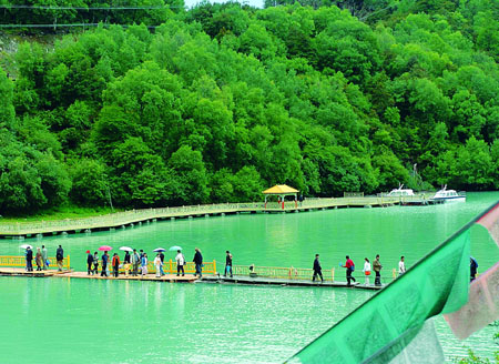
Nyingchi is known for its comparatively pleasant weather and beautiful scenery. Picture shows the Basum Co Scenic Area in Nyingchi.
Most of the lakes in Tibet assume blue cover and are crystal clear. Large ones are complete with islets, home to many birds. The bird islet in Banggong Co Lake in western Ngari is the most famous.
Famous lakes in Tibet include the Nam Co, Basum Co, Yamzhog Yumco, Sengli Co, Mapang Yumco and Banggong Co lakes.
Nam Co Lake. The largest lake in Tibet, it is situated between Damxung County of Lhasa, the capital city of the Tibet Autonomous Region, and Bangoin County of Nagqu Prefecture. It is the second largest salt lake in China.
Basum Co Lake. Located in Gongbogyangda County, the lake, also called Co Gor, was listed as a "world tourist attraction" in 1997, rated as a State 4A tourist area in 2001, and listed as a State forest park in 2002.
Yumzhog Yumco Lake. As the largest inland lake in the northern Himalayas, it is also the largest habitat for migratory birds in southern Tibet. The Yumzhog Yumco Pump-Storage Power Station built by the lake is the highest of its kind in the world. Its power station, with a fall of 800-odd meters, is complete with a water pumping channel extending close to 6,000 meters, and four hydroelectric generating units with a combined capacity of 90,000 kW. It is located 110 km from Lhasa City.
Sengli Co Lake. It is the number one lake in the world in terms of ele-vation. Located in Zongba County's Lunggar Town-ship, it has an elevation of 5,386 meters. The water surface covers 92 square km. There are close to 1,000 lakes each at an elevation over 4,000 meters in Tibet. They include 17 above 5,000 meters, of which Sengli Co is the highest.
Mapang Yumco Lake. Located some 200 km from Shiquanhe Town in Burang County, this is the highest freshwater lake in the world. With blue, crystal clear water, it is known as a holy lake together with Kangrenboqe.
Banggong Co Lake. Located north of Ritog County seat, the bulk of the lake is located within Chinese territory, with a small part in Kashmir.
In Tibet, most of the lakes are tinged with religious meaning. Nam Co, Mapang Yumco and Yamzhog Yumco are mentioned as the three major holy lakes. In addition, the region boasts Lhamo Lha Co Lake which enjoys a special place in the Living Buddha reincarnation system of Tibetan Buddhism, Dangro Yumco which is the soul lake of Living Buddha Razheng, and Cona Lake. |